
get it in PDF format
get it in PDF
format
by Gair
Tourtellot*, Jason Gonzalez** and
Francisco
Estrada Belli*
*Boston University
**Southern Illinois University,
Carbondale
Paper presented at the 64th Annual
Meeting, Society for American
Archaeology, Chicago, IL, March
27th, 1999
(Symposium: Classic Maya Society
and Natural Resource Use in the Three Rivers Area)
After five seasons at La Milpa in northwestern [locator
map]Belize, we begin to see the interaction of geography, landscape,
and culture at every scale. This morning we shall look first at how the
ancient Maya picked the location for La Milpa, then how they incorporated
landscape engineering, and finally how farmers modified their ground. This
afternoon Norman Hammond will present the cultural landscape [see page].
We are greatly aided by our GIS, which makes it possible to broadly contextualize
the site choice for La Milpa, from only a 6 percent sample. The regional
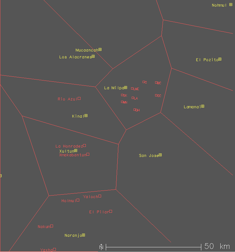
context of La Milpa provides seven location factors. [ Peten
Thiessens slide ] The political Thiessen territories show that
La Milpa is situated in a lattice of very widely spaced major sites. The
availability of gross space was Factor One in siting La Milpa. Factor Two
was incorporation of a diversity of natural resources.
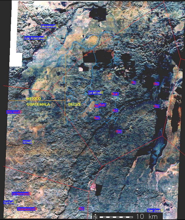
Within its 385 square kilometer polygon [ Thiessen on radar], the land forms near La Milpa comprise a long finger of upland from southwest to northeast, flanked to the north by wide bajo across to the Rio Azul, and flanked to the south by high escarpments and the Rio Bravo floodplain. Each major site incorporates a comparable transect across both upland and lowland resources. Factor Three was central location with respect to the diverse resources. La Milpa lies about halfway between the two sides of the upland strip, and is one of a string of sites along the "spine" from Blue Creek southwest to Kinal. We cannot yet confirm that La Milpa is also politically central to these sites, although that would account for the Late Classic primacy documented by its large size, 19 stelae, 20-plus courtyards, and some 46,000 people.
Corollary Factor Number Four was preference for upland terrain, the centrally located strip of high ground. This preference results, in part, from the fairly linear and parallel distribution of land forms. It also is the result of a demonstrable preference for well-drained soils. [ slide ]
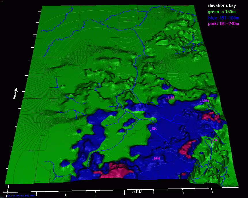
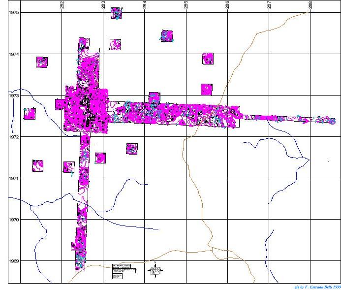
Proof is found by comparing the terrain of the 385 square kilometer polygon with the documented 78 square kilometers for the dense La Milpa community itself. -The black dots are structures, whose distribution indicates our survey areas.- While only 21 percent of the land within the La Milpa polygon lies above 150 meters, land within the community is fourty percent upland above 150 meters. This community also has much more sloping and hilly land than its larger polygon does.
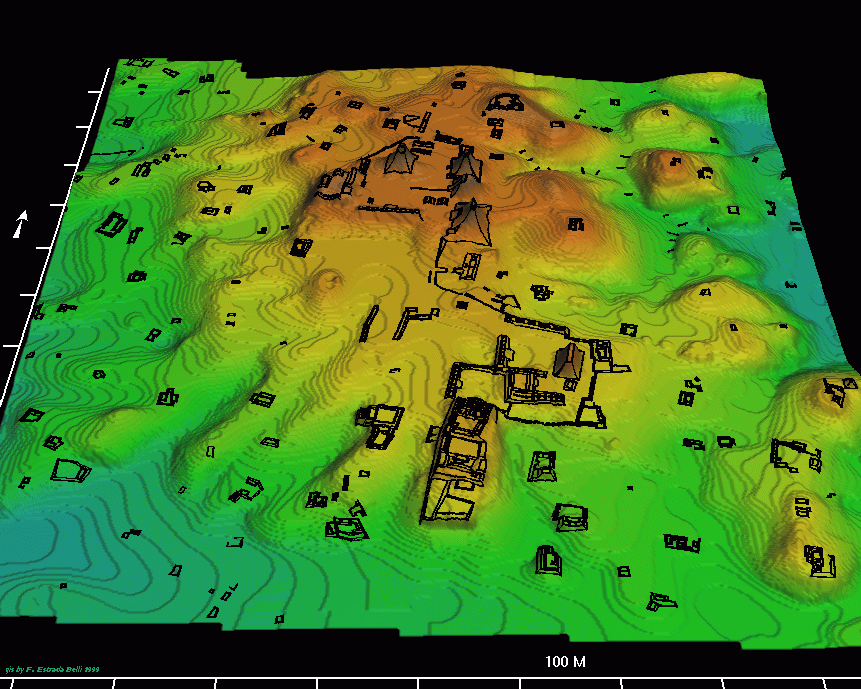
Drilling down, perhaps we can suggest why they chose the exact spot for the plazas of La Milpa Centre. It is well known that Maya ceremonial centers in the Southern Lowlands occupy local high ground, for many reasons. This elite preference is Siting Factor Five.
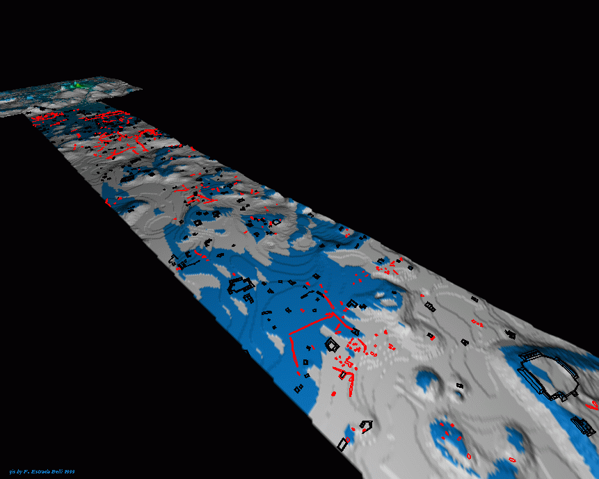
La Milpa Centre is indeed on the 180 meter contour plane that represents the majority of tall hills in the region. Although still higher altitudes, over 220 meters, do occur nearby away to the south along the scarp edge, they violate the centrality factor. [ slide ] Furthermore, compared to La Milpa, their summits are small and slopes very steep. Another 180-plus hill does occur 2 kilometers west of the present La Milpa Centre. We think this hill was not chosen for the main center because it is too narrow and steep-sided, has too much local bajo close aboard, and is not central to prime upland terrain. [slide: oblique 3D color view of whole CQ from south, with str. outlines]
Conversely, the La Milpa Centre hill, seen here, is broad, with lots of room for construction. That is Siting Factor Six. Lastly, Factor Seven is that the hill is also uniquely aligned north-south, thereby enabling that highly significant site orientation. In sum, La Milpa was sited to maximize access to upland terrain central to diverse resources, but was not sited directly on either bajos or water bodies.
During the Early Classic La Milpa was a compact hilltop town, with several pyramids, 4 stelae, perhaps a reservoir, and only a few widely scattered farmsteads!
[ slide]
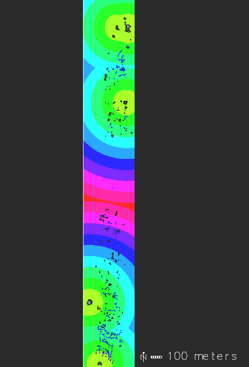
But in the Late to Terminal Classic a solid blanket of suburbs spread out to 5 klicks away, home for some 46,000 people. Okay, how did they organize this huge settlement on this rugged landscape? For two of our radial transects, crossing the suburban zone to the east and south from La Milpa Centre [point out on 3D slide], we have constructed a rank-size hierarchy of house-group sites . When the top four or five sites on each transect are plotted in respect to the central square kilometer of La Milpa, we get this spatial distribution. [ slide colored 1 km rings from LMC] Observe first that the top-ranking sites are rather evenly distributed, as if each might have controlled a small exclusive territory, about a kilometer across. Second, most top-rank sites are on hilltops, and about 50 percent of all house structures cluster closely around them. Third, observe that the size of these top-rank groups generally grows with distance from the center. This discovery nicely supports our proposition last year that the effective radius of direct elite control from the major center was only about 2 kilometers. Middle level sites like our top-rankers extended control further, and in detail.
Scattered between some 20,000 houses, we distinguish three types of stony features: [ slide: western ET E6500-7100 area] terraces (in light blue), berms and stony piles. Since these are the same things others have already shown today, we'll pass on to their settlement contexts.
First of all, almost all earthworks are Late to Terminal Classic. Second, earthworks do not occur anywhere on the main hill around La Milpa Centre; they are a feature only of the expansive late resettlement of La Milpa. Thirdly, we suspect earthworks and elite construction, everywhere else, also exhibit a similar, mutual repulsion. Returning to our rank-size hierarchy of house groups, [slide ] here is how the top-rank groups are associated with other structures-in black-and with the stony earth-works on the South Transect. Earth-works-the blue spaghetti here-are never directly associated with the prime groups, but are concentrated between 200 and 600 meters away from them, among many patio groups and smaller houses. [slide: ]
An even tighter pattern is observed on the East Transect, where two-thirds of earth-works occur between 300 and 500 meters from the top-rank groups. The first cause of this pattern is probably the association between stony earth-works, agriculture, and flatter ground. A second cause is the localized procurement and processing of the chert nodules from which the earth-works are made. Most earth-works are found on the margins of bajos or swales, where the footslope terraces, and maybe some of the berms, served to aerate soil. top-rank Meanwhile, the prime groups are usually on the summit above. This site removes the elite from direct association with industrial and field activities. It also reflects the operation on a more local level of Siting Factor Five, the elite Maya preference for high ground.
Finally, moving on down, we can examine how terraces and berms were involved in gardening activities in the subsistence system on the La Milpa upland. For this study we selected a low altitude study area one kilometer east of La Milpa Centre. [ slide] Jason performed a gross phosphate survey, taking soil cores on a 50 meter grid. [slide: phosphate contour/tone map-slide for his entire study area]
This survey yielded the general phosphate distribution patterns across the study area. It found high phosphates near household structures and at the base of slopes in flat areas, including behind footslope terraces. [map of Group1 ]
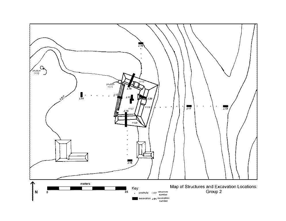
Two household groups were tested in detail. Group 1 produced results indicating that phosphate levels, and presumed gardening activites, were not uniform across the house lot. Phosphate was low in the eastern patio, as expected, but enriched immediately to the north, west, and south of the structures, presumably in patches of garden. The enrichment is likely to be due to deliberate use of night-soil, because ceramic counts are far too low for midden. Phosphate levels dropped to background levels further west towards Terrace 1124, but then rose again just behind the terrace, suggesting narrowly limited manipulation of soil fertility just behind the terrace. [photo slide of terrace/berm]
At Household Group 2 the excavations produced different results. [ Group 2 map] We found a much longer occupation sequence with lots more ceramics, houses of masonry, and different activities. The slopes to the north, east, and south of Group 2 are unlikely choices for garden areas, despite high phosphate percentages, due to their shallow soils, steep slopes, and lack of terracing. The drainage channel 25 meters to the east also contained some very high phosphate percentages and deep soils, although liable to wash-out. However, excavation 15 meters WEST of the patio yielded a prime candidate with flat, deep, and well drained soils, few rocks, and very high phosphate levels.
Lastly, a soil unit was placed in the flat semi-bajo to the north, for comparison. A nearly zero phosphate level suggests not only a lack of intentional soil enrichment 100 meters from the nearest house, but also activities removing phosphates from the natural soil nutrient structure. A likely cause is the practice of swidden agriculture in the bajo. Thus, during the Late/Terminal Classic period, the Maya appear to have had intensive gardens around their houses-on the slopes well below elite households-as well as possible agricultural fields in the low areas between the hills. However, more refined methods of soil analysis are needed to confirm these initial impressions. [view on ET slide ]
Summing up, we have looked at the landscape as an active dimension in the life of ancient La Milpa. We have outlined how we think the Milperos constructed their landscape: choosing the site, organizing its expansion, and finally intensifing their use of it.
Acknowledgments:
Research
by the La Milpa Archaeological Project has been actively assisted by The
Programme for Belize, owners of the Rio Bravo Conservation and Management
Area, graciously permitted by the Department of Archaeology of the Belize
Ministry of Tourism and the Environment, and generously funded by the National
Geographic Society, Boston University, and others. We thank co-director
Norman Hammond and the many staff, workers, and students who have contributed
immensely to our growing and changing knowledge of La Milpa. This paper
is an attempt to provide, along one axis of top to bottom analysis, a Big
Picture that encapsulates and justifies much of their hard work.
This page created by F. Estrada Belli on 3/29/99
For more info on this GIS dataset send email to Francisco Estrada Belli (fncesbl@bu.edu)
go the saa99 paper on ideology at LM![]()
go to B.U. Archaeology
page ![]()
or see
simulation on La Milpa Plaza A (5MB Quick time movie -download
free software here)