State Plans Makeover for Aging Comm Ave Deck
New construction will lead to detours for next two summers

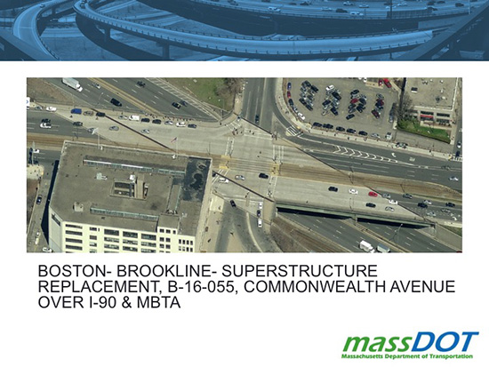
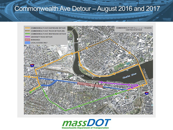
The Massachusetts Department of Transportation will be replacing a section of Commonwealth Avenue near the BU Central MBTA stop and the BU Bridge, with traffic detours planned for the next two summers (2016 and 2017). Most construction will be off site. Photos and graphics courtesy of MassDOT
A heavily trafficked section of Commonwealth Avenue, extending between the BU Bridge and Carlton Street, will be replaced and upgraded over the next two years by the Massachusetts Department of Transportation (MassDOT). “MassDOT is replacing the Commonwealth Avenue superstructure, also called the deck, due to its deteriorated condition,” says DOT spokesperson James Kersten, noting that the original deck is now 50 years old.
While most of the materials being used to construct the deck will be prefabricated off site and installed during the summers of 2016 and 2017, the bridge will be closed for about three weeks each of the two summers while the outbound and inbound sides are removed and replaced.
“The primary goal is to replace the entire superstructure and incorporate functional and safety improvements to the roadway,” Kersten says. Other goals include “providing a reliable bridge that is economical to maintain and providing acceptable bicycle, pedestrian, and wheelchair accommodations in accordance with current standards.”
The approximately $100 million project involves the replacement of the deck, at the intersection of the BU Bridge and Essex and Mountfort Streets, with the corners of the construction area at the Mass Pike (I-90) and the sidewalk areas of the BU Academy, the Engineering Product Innovation Center, 808 Comm Ave, and the grassy area at the Comm Ave entrance to the BU Bridge. A campus task force has been, and will continue to be, briefed on the details of the evolving project and is working with MassDOT to ensure that it proceeds smoothly, safely, and without disruption to BU community operations, according to Michael Donovan, BU vice president for real estate and facility services.

“The bridge will be closed to traffic while it is demolished, new structural steel is put in place, and a precast concrete deck is installed,” says Kersten, adding that to minimize the impact on the neighboring community, the superstructure will be replaced using what MassDOT calls “accelerated bridge techniques.” The replacement will be done during two separate mobilizations, each estimated to last from several weeks to a month. During that time, the public can expect detours and traffic disruption.
The eastern half of the deck, along with the MBTA Green Line portion of the deck, will be replaced during the latter half of July or the beginning to middle of August 2016, and the western half will be replaced during the latter half of July or beginning to middle of August 2017. The exact dates have not yet been finalized, as the design is still ongoing, according to MassDOT. This time frame was chosen using data collected by the state from past summer traffic flow, taking into account a variety of factors, including holidays and the Red Sox schedule. Based on that data, the Comm Ave construction should coincide with the period when there is the least amount of traffic on the roadways and most schools are not in session.
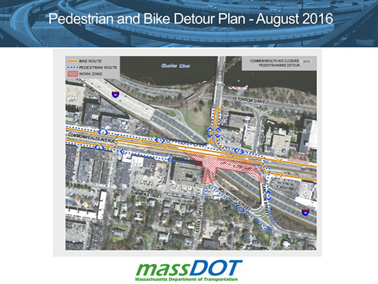
MassDOT has been careful to take into account those who travel this section of Comm Ave on foot, by car, or by bike by making improvements to pedestrian crossings at the intersection of Comm Ave and the BU Bridge, as well as at Comm Ave and Mountfort Street, with “a more articulated area for bicycle traffic and improved signaling for safer crossing by pedestrians,” says Kersten. In addition, the way the deck is being laid paves the way for planned, but not yet scheduled, improvements to the traffic flow pattern over the Carlton Street bridge, Mountfort Street, and the BU Bridge. A $3 million renovation of the BU Bridge was completed in 2012.

“This project is right in the heart of the campus,” says Donovan. “You’ve got pedestrians, cyclists, vehicular traffic, and public transit all using the deck. From an engineering and construction management perspective, it’s a challenging and ambitious project.”
The University and MassDOT have regular monthly project meetings to fine-tune the schedule and to “ensure that essential services and operations for the University continue during the project period,” Donovan says. “Our academic, research, housing, student life, and dining programs must have the ability to operate, and we’ve had discussions with the commonwealth regarding how we can continue to operate during the construction period.”
As the project gets closer, the meetings will become more frequent and more information will become available to the BU community. All major developments related to the project will be reported by BU Today.
Comments & Discussion
Boston University moderates comments to facilitate an informed, substantive, civil conversation. Abusive, profane, self-promotional, misleading, incoherent or off-topic comments will be rejected. Moderators are staffed during regular business hours (EST) and can only accept comments written in English. Statistics or facts must include a citation or a link to the citation.