![]()
Departments


![]()

|
Week of 7 January 2000 |
Vol. III, No. 18 |
Feature
Article
|
|
|
An animated image of the Terra
satellite, which will deliver a comprehensive
picture of the earth's surface every one to two
days for the next six years.
|
By Eric McHenry
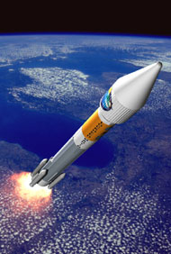
When a rocket carrying the Terra satellite rose on a cushion of flame from Vandenberg Air Force Base in California, two BU professors were looking on with proprietary pride.
The successful December 18 launch was a memorable event for Alan Strahler and Ranga Myneni, members of the CAS geography faculty who had contributed a combined 15 years to the development of the satellite's key research instrument. For the next six years, their work will help Terra deliver a comprehensive picture of the earth's surface every one to two days, assisting scientists and policymakers in their understanding of global environmental and climatic change.
"For us, it's a real turning point," Strahler said a few days before the launch. "We were part of this instrument long before it was built -- when it was just a bunch of specifications on paper for the kind of data we thought ought to be collected. The launch gives us a tremendous sense of fulfillment, because it's the moment that really crystallizes all of our work and makes it real. When that booster goes off, and thunder splits the air, and the ground shakes, and all the rest of the stuff they tell us is going to happen happens, it will be a very emotional moment."
"It was surreal," Myneni said, following the launch. "When the fellow counting it down got to 'one, liftoff,' there was a huge ball of fire, and the rocket hung in the air for what seemed like a long time before slowly ascending.
"It was the second greatest day of my life," he said. "The greatest was the day I got married; the second greatest was the day I saw this rocket lift off into the blue California sky."
Terra is the flagship satellite of the Earth Observing System, an ambitious program conceived by NASA scientists in the early 1980s. Its objective is to deploy a fleet of satellites that will gather data of unprecedented scope and quality on the ways human activity is affecting the earth's environment.
Strahler, CAS professor and chairman of the department of geography, and Myneni, CAS associate professor of geography, worked on the Moderate Resolution Imaging Spectroradiometer (MODIS), the satellite's key sensor. Both scientists are members of the MODIS Land Discipline Group, concerned with terrestrial phenomena.
Strahler led the development of two of the instrument's science data products. One will classify the earth's land surface based on the types of vegetation that cover it. The other will gauge albedo -- the total energy reflected from the earth's surface -- as well as reflectance at various angles.
"If you're walking across a parking lot on a sunny day," Strahler says, "you are probably noticing that a lot of energy is being conveyed from the ground to the air just above it. Albedo controls the energy flow between the earth's surface and the atmosphere, and has a great impact on weather. Our work will provide maps of surface characteristics, maps of albedo, so that regional climate modelers, who are looking at weather systems and predicting three, six, eight days in advance, can use extensive data that's quite recent."
This information, Strahler says, will also be valuable to the efforts of global climate modelers, who are interested in the long-term effects of human activity on weather patterns.
Myneni oversaw development of the MODIS Leaf Area Index (LAI) science data product, a measure of per-square-meter leaf coverage, which has many implications for the study of global climate change and its effects.
"Warm winters and warm springs lead to early greening, and the growing season gets longer," Myneni says. "MODIS will enable us to monitor the greenness of the planet from space much more accurately than previous instruments."
Myneni also created the Fraction of Photosynthetically Active Radiation (FPAR) algorithm, with which MODIS will register the percentage of solar energy that is being absorbed by vegetation.
"His products are really important," Strahler says of Myneni's work, "because they help us map photosynthesis, so to speak."
The Multiangle Imaging Spectroradiometer (MISR), another of the satellite's instruments, will assist in the gathering of both LAI and FPAR data. MISR will observe the earth simultaneously from nine different view angles.
Three junior BU faculty members helped bring the Terra program successfully to fruition. Mark Friedl, CAS assistant professor of geography, and Crystal Schaaf, CAS research assistant professor of geography, worked with Strahler on the land cover and albedo components. Juri Knjazihhin, CAS research associate professor of geography, worked with Myneni on both the LAI and FPAR. The project has also involved and partially supported a total of 25 BU graduate students since its inception.
According to Myneni, the satellite is functioning nearly perfectly thus far. NASA scientists expect the first images from MODIS and the other sensors in mid-January.
For more information about the Terra satellite, visit http://terra.nasa.gov. For more information about MODIS, visit http://ltpwww.gsfc.nasa.gov/MODIS/MODIS.html.