Lab session: Using GeoClaw
by Dr Donna Calhoun and Dr David George
Department of Mathematics, Boise State University (Calhoun) & U.S. Geological Survey (George)GeoClaw is an open-source code for the solution of wave propagation problems using depth-averaged equations. The code implements high-resolution finite volume methods (FVM) on rectangular grids, with adaptive mesh refinement (AMR). It is written in Fortran, with Python tools for the user interface and visualization.
Syllabus
Setting up a tsunami simulation using bathymetry and topography files and model earth- quake sources. Processing output to view simulations and estimate depth of inundation in coastal regions and to generate simulated DART buoy or tide gauge records.
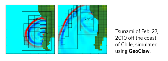
Example using the 2010 tsunami generated off the coast of Chile (LeVeque, 2011).
References
- M. Berger, D. George, R. LeVeque, K. Mandli, “The GeoClaw software for depth-averaged flows with adaptive refinement”, Adv. Water Res., 34(9):1195–1206 (2011) doi:10.1016/j.advwatres.2011.02.016
- F. I. Gonzalez, R. J. LeVeque, P. Chamberlain, B. Hirai, J. Varkovitzky, and D. L. George, “Validation of the GeoClaw model”, Tech. Report prepared for the National Tsunami Hazard Mitigation Program full text