Run, BU, Run!
Campus offers rich array of running routes
Most people don’t even try to schedule an appointment with John Snyder around lunchtime. Unless they’re wearing running shoes and clocking six-and-a-half minute miles.
“I almost always run at noon,” says Snyder, a College of Arts and Sciences chemistry professor, who can be found pounding the Charles River bike path even when the mercury pushes 95 degrees. “If it’s hot, I make sure my route goes past as many water fountains as possible.”
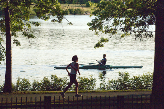
The BU campus offers access to a variety of running routes. Among the most popular is along the Esplanade and the Charles River. “My favorite run at BU is to get on the river and head west,” says Dennis Hart, BU’s associate general counsel. “I typically run at midday, but when things in the office get hectic, sometimes midday is 3 p.m.”
If you’re looking for some fun and scenic runs, here are a handful of convenient routes to try out during lunch — or any other time of day. Click here for printable maps.
Charles River runs
The Charles River loop is a 17-mile-plus biking and running path that extends from the Museum of Science nine miles upstream on both sides of the river to Watertown. With numerous bridges along the way, you can break the circuit into a run of almost any length, from a few miles to the whole 17-mile enchilada. Just head for the BU Beach behind Marsh Chapel and take the Bay State Road pedestrian bridge over Storrow Drive to the Dr. Paul Dudley White Bike Path. There’s also a pedestrian bridge at the end of Silber Way, formerly Sherborn Street.
 River run west (3.6 miles)
Bay State Road Pedestrian Bridge/Larz Anderson Bridge/BU Bridge
At the bottom of the pedestrian bridge, head west (the river will be on your right). After a mile or so, you’ll have to cross River Street and then Western Avenue, two well-traveled cross-city throughways. Cross the Larz Anderson Bridge, then head east. There’s plenty of riverbank running on the way back, and the hardworking scullers gliding across the water will keep you motivated. At Cambridge’s Magazine Beach, just before the BU Bridge, there’s a fitness cluster (although it’s in need of some maintenance) for push-ups and abdominal work on wooden incline boards. You’ll find a mix of dirt track and asphalt on the way out and dirt available most of the way back. Click here for a map.
River run east (5.4 miles)
Bay State Road Pedestrian Bridge/Museum of Science/Harvard Bridge
This route has no street crossings to navigate and plenty of dirt track. Head east after coming off the pedestrian bridge (the river will be on your left). There’s a fitness cluster at Soldiers Field Playground on the way out, or save some pull-ups for after your run. Not long after passing under the Harvard Bridge (also called the Mass Ave Bridge), an arched stone walkway on the left deposits you on a half-mile spit of island, with nice river views and cool breezes. Watch for tree roots, rocks, and green “goose cigars.” And give the goslings and mums plenty of room. Reconnect with the bike path near the Hatch Shell. Runners rave about the skyline views from the Cambridge side, especially when the sun sets over the Back Bay. You’ll find water fountains at the Community Boating Boathouse, Teddy Ebersol’s Red Sox Fields at Lederman Park, and BU’s DeWolfe Boathouse. Click here for a map.
Jamaica Pond loop (6 miles)
Marsh Chapel/Riverway/Jamaica Pond
This is one of the area’s greener runs, with lots of foliage, dirt track, and wooded trails. From Marsh Chapel, head south on St. Mary’s Street. Take a left on Mountfort Street and bear right onto Park Drive. Entrances for the Riverway path are located just past the Fenway T station tracks. At first, the lane is mostly dirt, and it snakes along the Muddy River and through Olmsted Park. There are several small roads to cross and a tricky intersection at Washington and River streets. A few rock-studded trails cut through the woods, allowing you to get in touch with your inner Vermonter while hopping fallen logs and stream beds. After about 2.2 miles, you’ll reach Perkins Street and Jamaica Pond, which is 1.8 miles around and offers several water fountains, including one at the boathouse. On weekend mornings, expect to dodge plenty of dogs, baby strollers, walkers, fishermen, and other runners. Click here for a map.
The Fens loop (2 miles)
Follow the directions above to Park Drive; instead of bearing right at the Riverway, stay straight on Park Drive and follow the green space into the Fenway. The Back Bay Fens loop is about two miles and marks the start of the city’s Emerald Necklace, a chain of linked urban parks designed by 19th-century landscape architect Frederick Law Olmsted. The mostly dirt footpath is wide and flat, passing the Museum of Fine Arts and several vegetable and flower gardens, including the country’s oldest operating wartime Victory Garden. Marshes and small stone bridges add to the hideaway feel. Tack this run onto either end of the Jamaica Pond loop for an eight-mile jaunt. Click here for a map.
For runs a little farther afield, try:
Harbor loop (9.5 miles)
Dorchester/South Boston waterfront
For a pleasant seaside run, hit the waterfront in South Boston. Take the subway to Park Street, change to the Red Line, and get out at the JFK/UMass station. Head east along Morrissey Boulevard toward Shaw’s supermarket. Cross the pedestrian overpass and continue east to the University of Massachusetts main entrance road. There you’ll find ocean-salted air, fat-bellied planes banking overhead from Logan International Airport, and the start of the waterfront trail.
Follow the shore along Savin Hill Cove, past the university and the John F. Kennedy Presidential Library and Museum. Continue around to Carson Beach, where you can run down by the water for a good stretch if it’s not too crowded with bathers. At City Point and Castle Island, also known as the “sugar bowl,” circle the causeway around Pleasure Bay. Pass Fort Independence and head back. A series of water fountains can be found along William J. Day Boulevard. This route offers a mix of asphalt and dirt track, plus a decent amount of grass. Click here for a map.
Boston Marathon lite (9.4 miles)
Newton/Brookline/Back Bay
The Boston Marathon is the world’s oldest annual marathon. This route takes in the final part of the race, including famous stretches, such as Heartbreak Hill and the Haunted Mile. Take the Green Line from Fenway station to Woodland station in Newton. The ride takes about 25 minutes.
From the T station, follow Washington Street to the right. At Commonwealth Avenue, make another right, past the fire station. This four-mile stretch through the Newton Hills is pedestrian-friendly, with dirt tracks cutting through wide grassy medians all the way to Boston College. This section includes Heartbreak Hill at the marathon’s 20.5-mile mark (the 3.5-mile mark for you), the only uphill part of the marathon course, more ill-timed than steep. Plenty of stately homes and fancy cars allow you to see how the other half lives.
After Boston College, you can divert around the Chestnut Hill Reservoir, which offers a 1.5-mile loop, or stick to the marathon course by bearing right onto Chestnut Hill Avenue toward Cleveland Circle. At this point, the course becomes distinctly urban, with plenty of asphalt, oblivious pedestrians, car exhaust, and traffic lights. Head left on Beacon Street to Kenmore Square, then pick up Commonwealth Avenue. As you turn right onto Hereford Street, picture the sidewalks 10-deep with cheering fans rather than surly meter maids and orange-vested men with jackhammers. Wheel left on Boylston Street for that final push to the Hancock building at Copley Square. There’s a CVS just after Dartmouth Street where you can pick up something to quench your thirst. Click here for a map.
 BU cross-country track team runs
For even longer runs, check in with BU’s cross-country track team. As a gift for Terrier coach Bruce Lehane, squad members Jochen Dieckfoss (CAS’04) and Jordan Jones (CAS’04) compiled a list of some 25 team runs that all start and end at Marsh Chapel, complete with maps and photos — from short morning routes to 15-milers. Lehane has been kind enough to share the wealth. Click here.
And Lehane’s favorite BU route?
“Up the Muddy River dirt path, across Boylston Street to the dirt path along Olmsted Park, across Jamaica Pond, and into the Arnold Arboretum paths,” he says. “That’s a good run for much of the year, as it provides softer footing, cover from the winds, shade, and a bit of respite from the pressures of the city.”
Caleb Daniloff can be reached at cdanilof@bu.edu.
Comments & Discussion
Boston University moderates comments to facilitate an informed, substantive, civil conversation. Abusive, profane, self-promotional, misleading, incoherent or off-topic comments will be rejected. Moderators are staffed during regular business hours (EST) and can only accept comments written in English. Statistics or facts must include a citation or a link to the citation.